
검색하기 및 사이트맵


INTRODUCING MT. GAYA
INTRODUCING MT. GAYA메뉴
AM 10:00 ~ PM 5:00
closed on Mondays
INTRODUCING MT. GAYA
- home
- INTRODUCING MT. GAYA


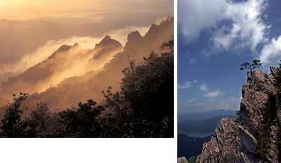
Mt. Gaya is a world renowned mountain that borders Seongju to the southwest and stretches to Seongju-gun of Gyeongsangbuk-do, and Hapcheon-gun and Geochang-gun of Gyeongsangnam-do. In 1972, Mt. Gaya was designated as a national park. It forms a ridge with peaks that are approximately 1,000 m in height, including the major of Chilbul Peak (1,433 m), Sangwang Peak, Mt. Namsan, Danji Peak, Namsan Peak 1, and Mt. Maehwa. Mt. Gaya is also known as one of the eight views of Joseon due to its very dynamic terrain.
If you follow the circulating road from Suryun-myeon to Mt. Gaya, you will come across a magnificent view of bizarre-looking cliffs in dark red facing the sky. Haeinsa Temple is the most famous temple in this area, as well as the Simwonsa Temple and Beopsusa Temple. In addition, there is a unique trail course of Yonggigol and Simwolgol that wind along the valley and waterfall. Yonggigol represents the magnificent and masculine beauty of Mt. Gaya and looks over the coming of Buddha beneath the Sky Rock.
The clear valley along the trail also adds to the charm of hiking. The trail from Simwongol to Yonggigol through Seoseongjae is filled with amazing things to see. The Sorbus alnifolia and painted maple trees are complementing the luxurious forests, while the wild squirrels and rabbits run around the mountain for the children and families to learn about nature. The bizarre-looking rocks that appear as if they are looking down from the peak, along with the autumn leaves, allow you to experience the wonders of nature, while the snowy view of Mt. Gaya in winter appears as a piece of landscape painting.
Mt. Gaya National Park
- Designated : Designated as a national park (1972) and Baegun community facility(1984)
- Location : Masu-ri, Singye-ri, Beopjeon-ri of Gacheon-myeon, Baegun-ri Guryun-myeon
- Altitude : 1,433 m above sea level (Main Peak: Chilbulbong)
- Area : 60.56 ㎢ (37 ㎢ of Seongju-gun takes 61% of Mt. Gaya)
- Tourist Attractions : Baegundae, Seojangdae, Dongjangdae, Yonggisaji, Simwonsa, Beopsusaji, Manmulsang, Pocheon Valley, etc.
- Trails : Simwongol, Seoseongjae, Yonggigol (about 3 hours), Peak Course (about 4hours)
- Traffic : Daegu Seobu Station → Baegun-dong (08:20; 17:50), Daegu Bukbu Station → Baegun-dong (14:20)
Chulbulbong, the Highest Peak of Mt. Gaya
It has been found that the highest peak of Mt. Gaya, which is a renowned mountain of Yeongnam due to its beautiful natural views, is not Sangwangbong, but Chilbulbong in Seongju-gun.
Since the Japanese Imperial Rule, the hikers of Mt. Gaya and the local people have argued whether the highest peak of Mt. Gaya is Sangyangbong or Chilbulbong. This is due to the fact that Chilbulbong is indistinctively similar to Sangwangbong in height.
Most administrative maps, as well as the other maps that are currently in use, mark the peak of Mt. Gaya as Sangwangbong, which rises 1,430 m above sea level (also known as Udubong). The district office internally measured the peaks last May in order to search for the real peak and decided that Chilbulbong is higher than Sangwangbong. They requested the National Geographic Institute to perform an official survey. According to the National Geographic Institute's response regarding the altitude of Mt. Gaya (June 7, 1999), they performed an accurate aerial survey and officially announced that Chilbulbong in Seongju, which is 250 m from Sangwangbong (1,430 m) in lineal distance, is higher by 3 m (1,433 m). They will reflect this when they make the necessary corrections to the topographic maps in the future.